


MapTiler Mobile
Deskripsi MapTiler Mobile
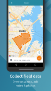
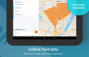
See your GPS position on your own maps. Draw points, polygons and lines on the maps. Collect field data and notes related to a location, attach a photo and fill custom properties.
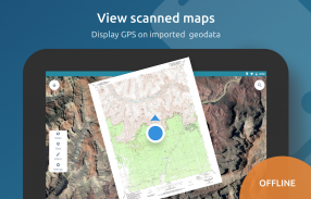
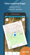
Display offline maps generated with MapTiler (https://www.maptiler.com).
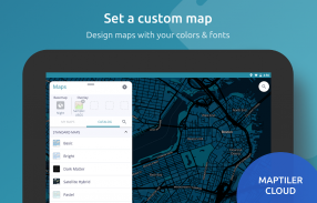
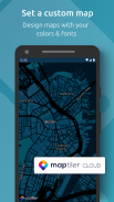
Choose from various basemaps like street and satellite. Preview on a mobile device the map you previously designed with own colors and fonts in MapTiler Cloud.
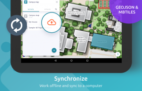
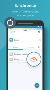
The app supports GeoJSON and MBTiles formats and data synchronization between multiple devices and desktop computer using cloud. I it easy to share the data with other people and collaborate! Perfect for mobile data collection for GIS and surveys.
Import scanned hiking maps, PDF maps, drone aerial imagery, nautical charts for sailing and navigation with a boat or a yacht, fishing maps, aeronautical charts for flight planning by pilots, parcels and city plans and other opendata from local government. OpenStreetMap vector maps are powered by OpenMapTiles project (the successor of OSM2VectorTiles). Maps can come from existing tile servers with OGC WMTS, TileJSON or XYZ tiles from.
Supported geodata formats by MapTiler: GeoTIFF, TIFF, JPEG, ECW, SID / MrSID, NOAA KAP / BSB, DEM, OziExplorer OZI OZF2 & OZFX3, WebP, JP2, JPEG2000, GeoJP2, Erdas, Grass, Safe, Sentinel2, SRTM, NASA imagery, USGS map sheets, exports from ESRI ArcGIS, ArcSDE, etc.
The GeoJSON can be converted from / to: ESRI ShapeFile (SHP), DXF, DWG, GPX, CSV and KML.
Lihat posisi GPS Anda di peta Anda sendiri. Gambar titik, poligon, dan garis pada peta. Kumpulkan data lapangan dan catatan yang terkait dengan lokasi, lampirkan foto, dan isi properti khusus.
Tampilkan peta luring yang dihasilkan dengan MapTiler (https://www.maptiler.com).
Pilih dari berbagai peta dasar seperti jalan dan satelit. Pratinjau pada perangkat seluler peta yang sebelumnya Anda desain dengan warna dan font sendiri di MapTiler Cloud.
Aplikasi ini mendukung format GeoJSON dan MBTiles dan sinkronisasi data antara beberapa perangkat dan komputer desktop menggunakan cloud. Saya mudah berbagi data dengan orang lain dan berkolaborasi! Sempurna untuk pengumpulan data seluler untuk GIS dan survei.
Impor peta hiking yang dipindai, peta PDF, citra udara drone, peta laut untuk berlayar dan navigasi dengan kapal atau kapal pesiar, peta penangkapan ikan, peta aeronautika untuk perencanaan penerbangan oleh pilot, paket, dan rencana kota serta opendata lainnya dari pemerintah daerah. Peta vektor OpenStreetMap didukung oleh proyek OpenMapTiles (penerus OSM2VectorTiles). Peta dapat berasal dari server ubin yang ada dengan ubin OGC WMTS, TileJSON atau XYZ.
Format geodata yang didukung oleh MapTiler: GeoTIFF, TIFF, JPEG, ECW, SID / MrSID, NOAA KAP / BSB, DEM, OziTeksplorer OZI OZF2 & OZFX3, WebP, JP2, JPEG2000, GeoJP2, Erdas, Grass, Safe, Sentin2, NASA citra, lembar peta USGS, ekspor dari ESRI ArcGIS, ArcSDE, dll.
GeoJSON dapat dikonversi dari / ke: ESRI ShapeFile (SHP), DXF, DWG, GPX, CSV dan KML.
MapTiler Mobile - Versi 2.0.1
(12-03-2020)MapTiler Mobile - Informasi APK
Versi APK: 2.0.1Paket: com.maptiler.geoeditorVersi Terakhir dari MapTiler Mobile
Versi lain


 4.34
4.34


 4.63
4.63
Aplikasi pada kategori yang sama

Anda juga mungkin suka...
Aplikasi pada kategori yang sama


